El Fwonk Casanosia: Difference between revisions
King Horror (talk | contribs) No edit summary |
King Horror (talk | contribs) No edit summary |
||
| Line 5: | Line 5: | ||
The exact borders of what constitutes “El Fwonk Casanosia” have also changed may times, especially its eastern bounds. The Permechikan Desert makes for a difficult boundary to define, despite several attempts to do so, including walls and military garrisons. | The exact borders of what constitutes “El Fwonk Casanosia” have also changed may times, especially its eastern bounds. The Permechikan Desert makes for a difficult boundary to define, despite several attempts to do so, including walls and military garrisons. | ||
== Ecology and Geography == | |||
(see [[Fwonnel Peninsula]] for more details) | |||
The majority of El Fwonk Casanosia is located on the Fwonnel Peninsula, which has very rugged terrain, ranging from hilly to sharply mountainous. The ecosystem is overall subtropical, with some areas being wetland, others being monsoonal desert, and others being alpine forest. | |||
The ecology of El Fwonk Casanosia is entirely dependent on the water that comes from the [[Great Geyser Lake]], an enormous series of springs located along the [[Irkun Fault]] that create the [[Prins River]] and its tributaries. | |||
A series of large lakes and streams exist throughout the peninsula, most of which lead to the [[Death Canyon River]] and [[Death Canyon Delta]] at the northwest corner of the [[Froof Straits]]. Most of the lakes and rivers were not natural - they were dammed up, dug, and dredged by countless generations of [[Pups]] going back thousands of years. The most recent significant change to the map of El Fwonk Casanosia was the 1836 AR Flattening of [[Mount Supuksis]] by the Permechikan Empire, linking together the islands of [[Fwonn]] and Fishtail. | |||
Revision as of 16:59, 10 October 2025
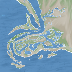
El Fwonk Casanosia (Arodjun: Ezle Fwonk K'sleinozlja) refers to the state, or collection of states, that occupy the territory of the Fwonnel Peninsula, as considered by Arodjun-speaking pups, since the region's independence from the Permechikan Empire in 1845 AR.
Since its initial independence, El Fwonk Casanosia has existed in multiple forms and been formally or informally dissolved during times of crisis or foreign occupation several times. See Timeline of the Fwonnel Peninsula for a simple visualized breakdown. The majority of the time after 1845, however, the nation has been at least nominally unified by the Charter of El Fwonk Casanosia, a foundational legal document.

The exact borders of what constitutes “El Fwonk Casanosia” have also changed may times, especially its eastern bounds. The Permechikan Desert makes for a difficult boundary to define, despite several attempts to do so, including walls and military garrisons.
Ecology and Geography
(see Fwonnel Peninsula for more details)
The majority of El Fwonk Casanosia is located on the Fwonnel Peninsula, which has very rugged terrain, ranging from hilly to sharply mountainous. The ecosystem is overall subtropical, with some areas being wetland, others being monsoonal desert, and others being alpine forest.
The ecology of El Fwonk Casanosia is entirely dependent on the water that comes from the Great Geyser Lake, an enormous series of springs located along the Irkun Fault that create the Prins River and its tributaries.
A series of large lakes and streams exist throughout the peninsula, most of which lead to the Death Canyon River and Death Canyon Delta at the northwest corner of the Froof Straits. Most of the lakes and rivers were not natural - they were dammed up, dug, and dredged by countless generations of Pups going back thousands of years. The most recent significant change to the map of El Fwonk Casanosia was the 1836 AR Flattening of Mount Supuksis by the Permechikan Empire, linking together the islands of Fwonn and Fishtail.
